Please click here to see the trails on a map
 A
bridleway is a highway over which the public can travel on foot or on horseback.
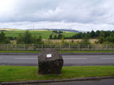
Bridleway 9 is about 6.5 km long, starting on Onllwyn Road passing through
Heol Hen, Seven Sisters and ending at Path 4 at the old Crynant Colliery,
Creunant.
A
bridleway is a highway over which the public can travel on foot or on horseback.
Bridleway 9 is about 6.5 km long, starting on Onllwyn Road passing through
Heol Hen, Seven Sisters and ending at Path 4 at the old Crynant Colliery,
Creunant.
Virtual walk in pictures along Bridleway 9
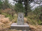
 The
Brecon Forest Tramroad linked collieries around Onllwyn to limestone quarries
at Penwyllt, and carried lime north to Sennybridge to improve the land in
the upper Usk valley. When the rural market for coal and lime proved to be
limited, the line was extended southwards to the Swansea Canal enabling a
more profitable line in coal exports to be pursued. Joseph Claypon took over
the tramroad in 1827 and extended it southwards to Gurnos. The line continued
to function until 1863 when the Neath to Brecon Railway was opened.
The
Brecon Forest Tramroad linked collieries around Onllwyn to limestone quarries
at Penwyllt, and carried lime north to Sennybridge to improve the land in
the upper Usk valley. When the rural market for coal and lime proved to be
limited, the line was extended southwards to the Swansea Canal enabling a
more profitable line in coal exports to be pursued. Joseph Claypon took over
the tramroad in 1827 and extended it southwards to Gurnos. The line continued
to function until 1863 when the Neath to Brecon Railway was opened.
Virtual walk in pictures along Claypon's Tramway
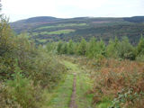
 This
walk marks the route of a Roman military road, Sarn Helen, which ran the
length of Wales from Neath (Nidum) in the south to Caernarfon (Segontium)
in the north. A section of this road connecting the forts at Neath and Coelbren
traverses the ridge of Hirfynydd where walkers can follow in the sandaled
footsteps of Roman soldiers.
This
walk marks the route of a Roman military road, Sarn Helen, which ran the
length of Wales from Neath (Nidum) in the south to Caernarfon (Segontium)
in the north. A section of this road connecting the forts at Neath and Coelbren
traverses the ridge of Hirfynydd where walkers can follow in the sandaled
footsteps of Roman soldiers.
Virtual walk in pictures along Sarn Helen
 St
Illtyd lived in the late fifth and early sixth centuries, and was held in
high veneration in Wales, where many churches were dedicated to him in Glamorgan.
St. Illtyd’s Way also forms part of the modern, St. Illtyd’s
Walk - extending 64 miles from Margam (in Glamorgan) to Pembrey (in Carmarthenshire).
This section links the Neath Valley with the Swansea Valley.
St
Illtyd lived in the late fifth and early sixth centuries, and was held in
high veneration in Wales, where many churches were dedicated to him in Glamorgan.
St. Illtyd’s Way also forms part of the modern, St. Illtyd’s
Walk - extending 64 miles from Margam (in Glamorgan) to Pembrey (in Carmarthenshire).
This section links the Neath Valley with the Swansea Valley.
Copyright © 2025 Dulais Valley Partnership